Excessive Rainfall Discussion
NWS Weather Prediction Center College Park MD
840 PM EDT Wed Jul 3 2024
Day 1
Valid 01Z Thu Jul 04 2024 - 12Z Thu Jul 04 2024
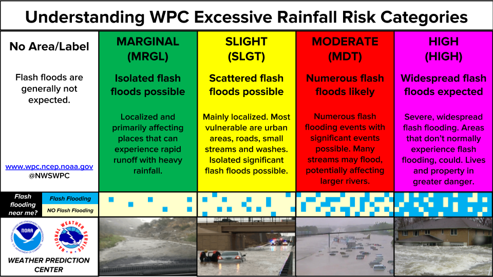
...THERE IS A SLIGHT RISK OF EXCESSIVE RAINFALL OVER PORTIONS OF
THE CENTRAL PLAINS EASTWARD TO THE OHIO VALLEY|...
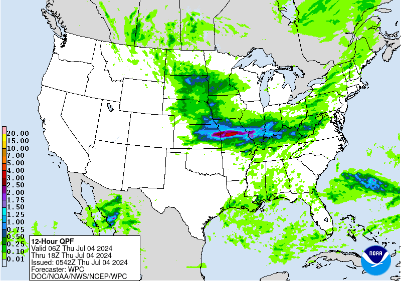
...0100 UTC Update...
Changes to the previous outlook were based on the latest radar
trends and the latest trends from the past several runs of the HRRR.
The marginal risk across the Central Plains was trimmed to the
south into southeast NE. The marginal and slight risk area over the
Upper OH Valley were trimmed significantly to the south to a
position along the OH/WV border based on radar trends. The primary
slight risk running west to east from the Central Plains into the
Lower MO Valley and Mid MS Valley was narrowed given latest HRRR
precip axis with the expected overnight convection. This narrower
axis also corresponds well with the 1800 UTC HREF neighborhood
probabilities for 1 and 2"+ amounts in the 0000 - 1200 UTC July 4th
period.
Oravec
...16Z Update...
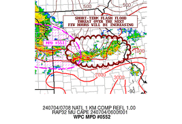
Previous SLGT risk forecast remains on target with an elevated
flash flood risk positioned across southern KS through southern MO
with an emphasis over south-central and southeastern MO. Remnant
outflow from nocturnal convection is currently analyzed across
southern MO and will be the focal point for afternoon and evening
convection with heavy rainfall likely given the antecedent
environment. PWATs over 2" are aligned along and ahead of the
quasi-stationary front across KS into MO, as well as within the
confines of the aforementioned lingering outflow. 12z HREF
neighborhood probabilities are favorable for at least 3" of
rainfall across much of south-central MO to the KS/MO state line
with values settling between 45-70% within that corridor. This
correlates well with the elevated probabilities for at least 2"/hr
rain rates suggested within the latest hi-res ensemble suite
(25-40%). The above area will run on the higher end of the SLGT
risk threshold with a non-zero chance at a targeted upgrade later
pending how convection evolves. For now, the signals are strong
enough for the current forecast, but a bit under what we would want
to see for a higher forecast risk area.
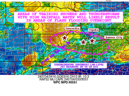
The SLGT risk was extended through portions of the Ohio Valley as
the quasi-stationary front will be a target for convective
development later this evening within a secondary tongue of
elevated theta-E's being advected northeast into southern OH. CAMs
are leaning towards the possibility of scattered heavy rain
signatures within areal convective development. The signal for at
least 2" of precip within that area of OH has risen since the last
update, indicative of the evolving pattern with favorable
thermodynamics overlaid across that portion of the Ohio Valley.
Rates between 1-2"/hr are plausible within this corridor, enough to
be a signal for 1hr FFG exceedance within the latest hi-res
ensemble. This was enough to necessitate the extension through
portions of southern OH and adjacent KY.
There are no changes to the MRGL risk area across the Southwest as
a monsoonal setup is still forecasted to evolve later this
afternoon with isolated flash flooding possible, especially in
complex terrain and burn scars present.
Kleebauer
...Previous Discussion...
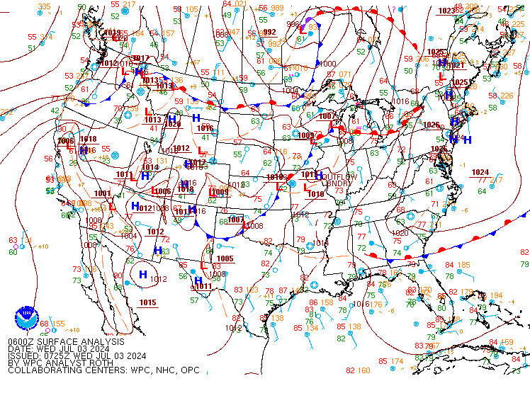
...Mid Mississippi Valley and Great Plains...
A cold front from a passing trough over the northern tier of states
will stall in the vicinity of Kansas and Missouri later today,
providing focus for renewed thunderstorm development from eastern
Kansas and southern and central Missouri eastward into the Lower
Ohio Valley. Except for a few adjustments based on the latest suite
of global and ensemble guidance from the 03/00Z model runs...there
Slight Risk area was largely unchanged from the previous issuance.
The guidance still depicts strong instability (CAPE in excess of
2000 j/kg) and PWs in excess of 2 inches (above the 95th
percentile) combining to support organized convection with rain
rates exceeding 2 inches per hour at times combining with the
potential for cell training or backbuilding.
Elsewhere the Marginal Risk areas were generally maintained in the
Upper Ohio Valley and Northern Plains where low chances of heavy
rain rates and flash flooding persist.
...Southwest...
Continued to trim the Marginal risk area as mid- and upper-level
heights continue to build into the region....helping to suppress
late day and evening convection even further.
Bann
Day 1 threat area:
www.wpc.ncep.noaa.gov/qpf/94epoints.txt
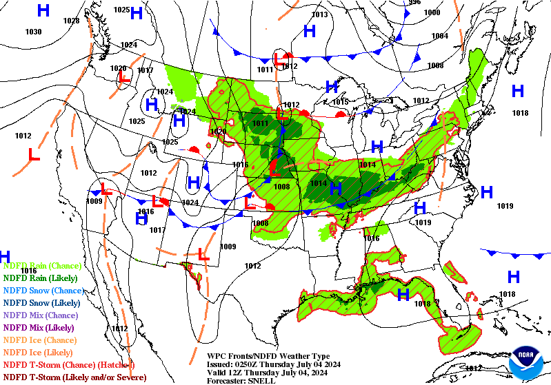
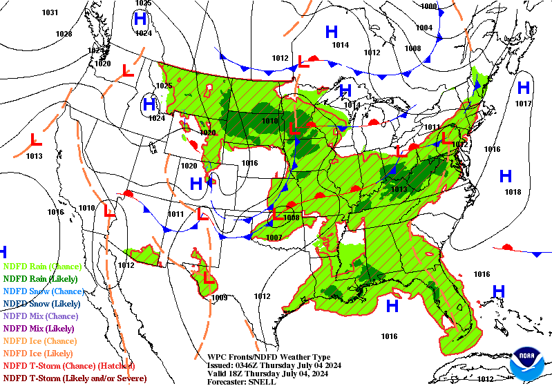
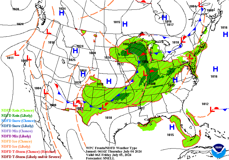
Excessive Rainfall Discussion
NWS Weather Prediction Center College Park MD
455 AM EDT Thu Jul 4 2024
Day 1
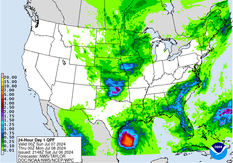
Valid 12Z Thu Jul 04 2024 - 12Z Fri Jul 05 2024
...THERE IS A SLIGHT RISK OF EXCESSIVE RAINFALL OVER PORTIONS OF
THE MISSISSIPPI VALLEY...
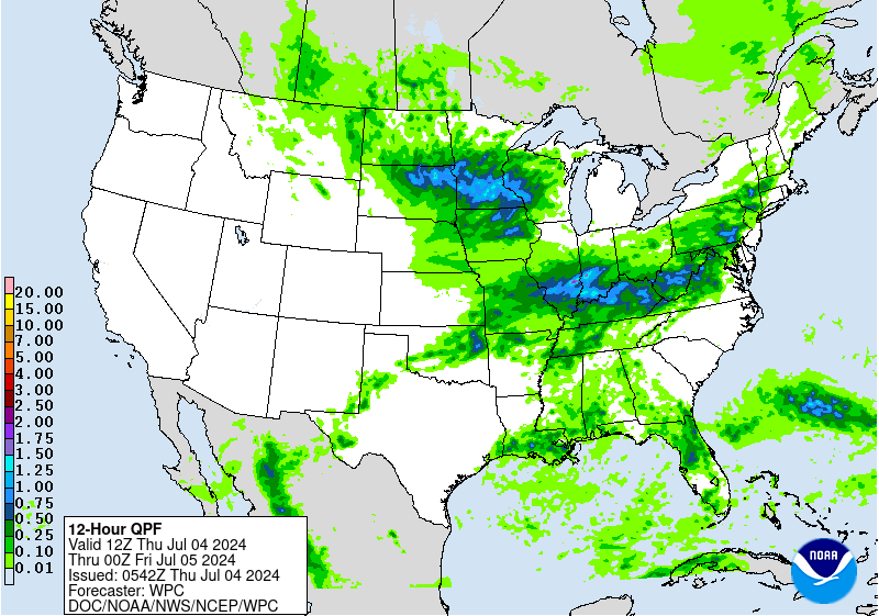
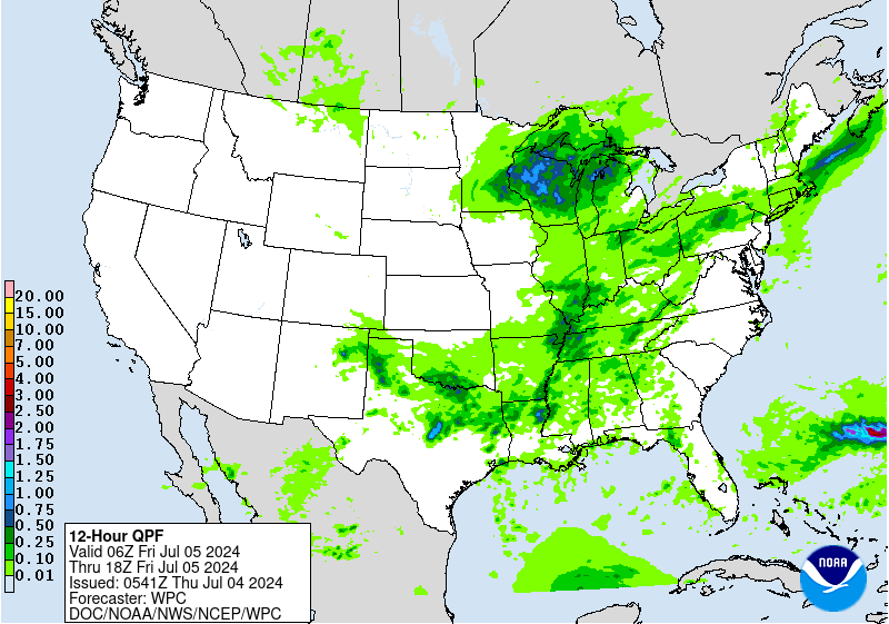
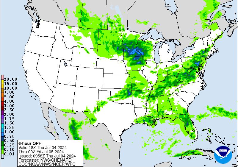
...Oklahoma, Missouri and into southern Indiana...
Organized convection will likely be ongoing at 12z this morning
across portions of central MO and southern IL...moving into
southern IN through the morning hours. Some west to east training
of convection is expected to be ongoing at 12z, resulting in a
flash flood risk through the morning hours. By late morning
activity is expected to become a bit more progressive and linear in
nature, which should result in a gradual decline in the flash
flood threat.
Additional convective development is likely by later in the
afternoon along the cold front from eastern OK into southern MO.
While the bulk of this activity should remain progressive in
nature...there may be an opportunity for some training across
southern MO into southern IL where cell motions could be more
parallel to the frontal zone. The bulk of this second round should
stay just south of the first round that is occurring Wednesday
night into Thursday morning...but there may be some overlap over
portions of MO and IL. This combined with some training potential
suggests an isolated to scattered flash flood risk likely exists
between ~00-09z tonight along this corridor. The flood risk is
probably a bit lower over eastern OK...as the combination of more
progressive cells and higher FFG suggests less of a threat. However
there is some mid and upper forcing that hangs back over this
area, suggesting some chance for multiple rounds of convection to
move across. Thus not confident enough to remove the Slight risk
and so will let it ride over this area as well.
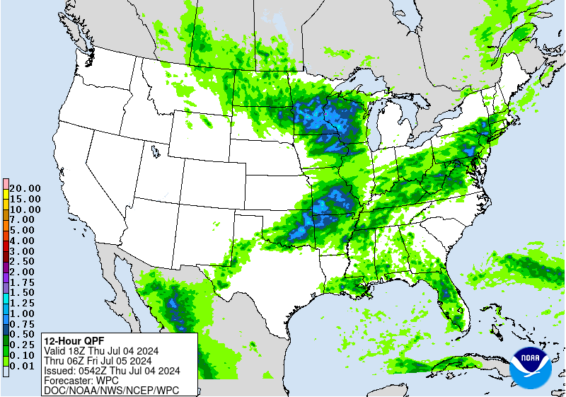
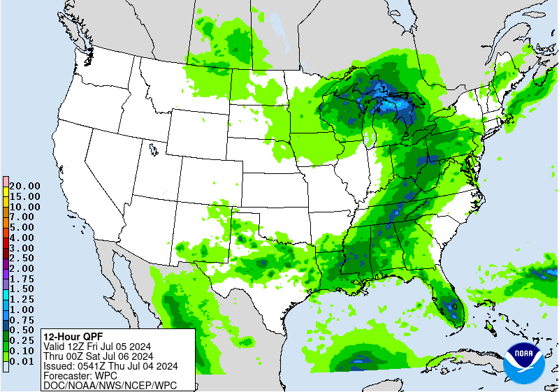
...South Dakota into Wisconsin...
A swath of heavy rainfall is likely today across portions of
eastern SD into central/southern MN, northern IA and WI. This will
be a very dynamic system with strong large scale forcing and lower
level convergence near a stationary front. Moisture and
instability are more marginal, as being a northern stream dominant
system we do not really have a deep moisture connection from the
sub tropics. Nonetheless, high res models do suggest instability
could approach 2000 J/kg near the front from northern IA into
southern MN into WI...and PWs do increase towards and even above
1.5". Thus while rainfall efficiency will not be as high as it
could be...still plenty of instability and moisture to drive some
heavy rainfall rates of 1-2"/hr (as indicated by most high res
models).
Given the strong forcing in place...likely to have rather
widespread coverage of showers and thunderstorms...although the
exact convective evolution remains uncertain. HREF EAS probabilities
of 1" over the 24hr period are above 50%....which is indicative of
the large 1" QPF footprint that is expected. However 2" EAS
probabilities drop into the 10-20% range suggesting much lower
coverage of 2"+ amounts. Neighborhood probabilities of 3" are
around 50% though...so combining these two probabilistic fields
indicate an event where higher end (2-4") amounts are probable, but
the coverage of such amounts should stay pretty isolated in
nature. Overall this is a solid Slight risk event...and given the
saturated conditions over this area...the event is probably getting
close to higher end Slight risk territory. The aforementioned
limited coverage keeps this below MDT risk levels...but with
widespread 1-2" and isolated 2-4" amounts expected over sensitive
areas...do expect that isolated to scattered flash flooding will
be a concern today.
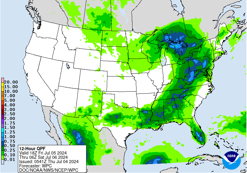
...Mid-Atlantic...
A broad Marginal risk extends from the OH Valley into the Mid-
Atlantic. PWs are expected to be quite high today across the
region...in fact we may be looking at 95th-99th percentile PWs
across portions of the region. Forcing to help initiate an
organize convection is more questionable. Generally lacking a
pronounced forcing mechanism, although do note some weak mid level
height falls and we will have a dissipating cold front moving into
the region. Most HREF members show at least isolated to scattered
convective development, although there is not great spatial
agreement amongst the models. The forecast instability and moisture
support heavy rainfall rates, but it remains unclear on if/where
any organization to convection may drive a greater flash flood
threat. Thus for now a broad Marginal risk should suffice, with
environmental ingredients supporting an intense rainfall rate
driven flash flood risk...but expected coverage remaining below
Slight risk thresholds at this time.
Chenard
Day 1 threat area:
www.wpc.ncep.noaa.gov/qpf/94epoints.txt
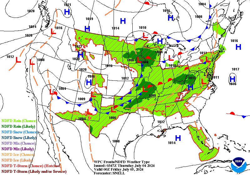
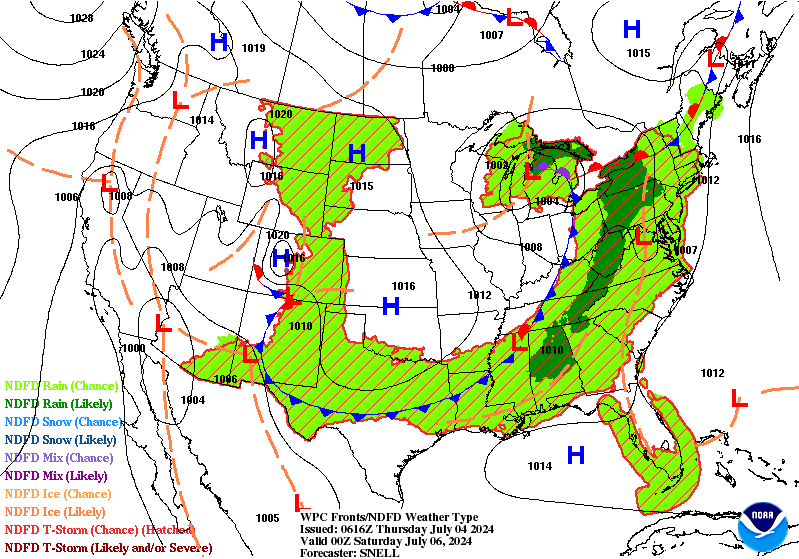
Excessive Rainfall Discussion
NWS Weather Prediction Center College Park MD
455 AM EDT Thu Jul 4 2024
Day 2
Valid 12Z Fri Jul 05 2024 - 12Z Sat Jul 06 2024
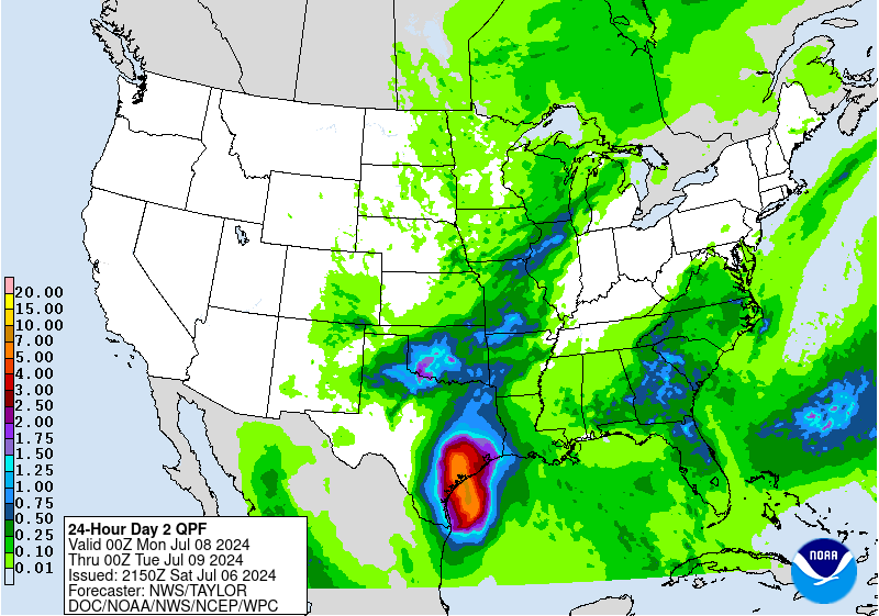
...THERE IS A MARGINAL RISK OF EXCESSIVE RAINFALL OVER MUCH OF THE
SOUTHERN AND EASTERN U.S....
At least scattered convective development is likely along and ahead
of a cold front stretching from TX into New England. PWs are
forecast at or above the climatological 90th percentile over most
of this frontal zone...with upwards of 2000 j/kg of CAPE possible
along the extent of the front. Enough mid level troughing and
upper jet support to drive decent convective coverage as well. So
looking just simply at convective coverage, instability and PWs,
would support localized areas of heavy rainfall and flash flooding.
This assessment is also supported by the CSU machine learning ERO
which depicts a broad Marginal risk. Not seeing much in the model
QPF fields or environmental fields to really indicate where/if any
more organized and higher end rainfall event could occur. Instead
indications are that flash flood concerns generally stay isolated
in nature...confined to where heavy rates overlap an urban or other
sensitive area...or where cell mergers result in a locally
increased duration of higher rainfall rates. Would not be surprised
if somewhere within this broad risk sees Slight risk type
coverage/impacts...but at this lead time we do not have the
confidence to pinpoint exactly where.
Eastern NM should also see an uptick in convective coverage
Friday, with post-frontal upslope flow helping aid in development.
This is also a region where a focused Slight risk may eventually
need to be considered.
Chenard
Day 2 threat area:
www.wpc.ncep.noaa.gov/qpf/98epoints.txt
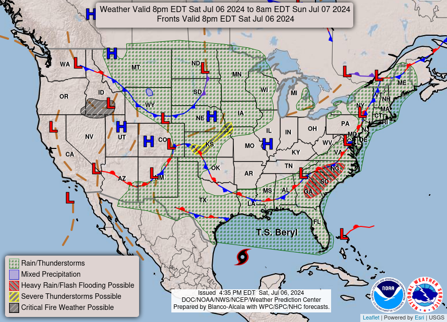
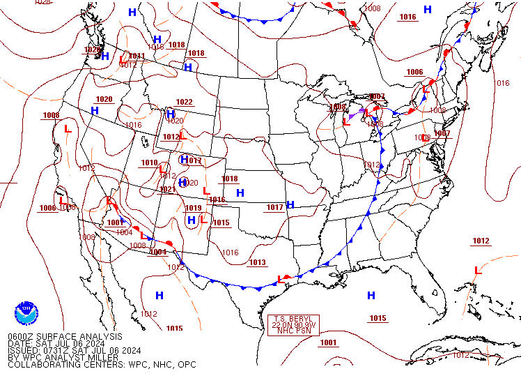
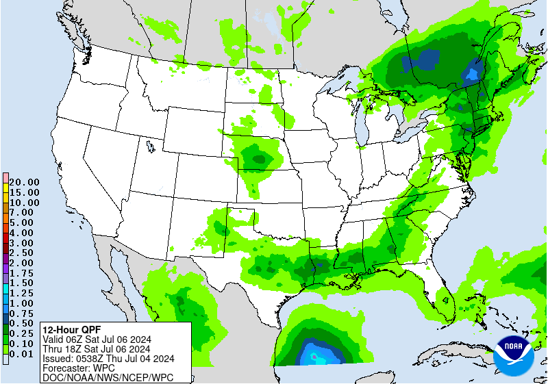
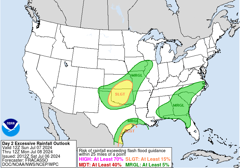
Excessive Rainfall Discussion
NWS Weather Prediction Center College Park MD
455 AM EDT Thu Jul 4 2024
Day 3
Valid 12Z Sat Jul 06 2024 - 12Z Sun Jul 07 2024
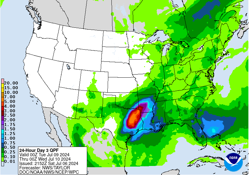
...THERE IS A MARGINAL RISK OF EXCESSIVE RAINFALL ACROSS PORTIONS
OF THE SOUTHERN AND EASTERN U.S. AND OVER THE CENTRAL PLAINS TO TO
THE MID/UPPER MISSISSIPPI VALLEY...
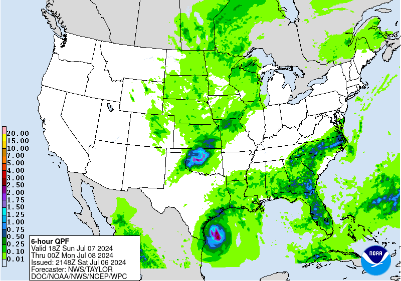
The front mentioned in the day 2 discussion shifts off to the
southeast on Saturday. Would again expect to see at least
scattered convective development along the boundary from TX into
the eastern Mid-Atlantic. There is a bit more uncertainty on the
location of the front by this time...but have noted a bit of a
quicker trend in the newer models/ensembles. This would push the
threat closer to the Gulf Coast on the southern extent, and closer
to the East Coast on the eastern side. It is possible that an
isolated risk could exist over New England, but there is even more
uncertainty on the timing of the front and thus location of better
instability and moisture...so opted not to include these areas in
the Marginal at this time. Direct impacts from Beryl should not
impact the country through Saturday night...however some moisture
ahead of the system could start to interact with the frontal
boundary over TX. Thus will need to keep an eye on the potential
for an enhancement of convection and QPF along the southwestern
flank of this front.
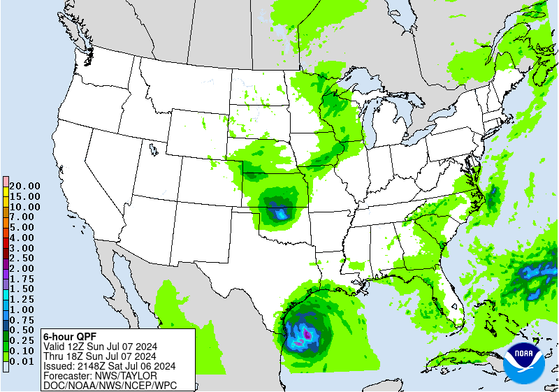
A Marginal risk also extends from portions of NE into southern MN.
Broad troughing remains over the central U.S, and guidance
indicates a mid level shortwave should be diving south within the
long wave trough. There is also a response in the upper jet, and
overall large scale synoptic support for ascent looks pretty good
by Saturday night. Not surprising that we also see a low level
response to this increased forcing, with 850mb moisture transport
seeing a notable uptick. Moisture looks to be a limiting factor,
as still not seeing a great deep layer moisture connection, and so
PWs are only forecast around average levels. Absent wet antecedent
conditions this setup may not warrant any risk at this
point...however with much of this part of the country well above
average for rainfall of late...any organized convective setup
likely poses at least some flash flood risk. And despite only
modest moisture...the strong forcing should make up for this and
allow for some potentially heavy rainfall totals. The GFS is
displaced a bit north of the better model clustering seen in the
ECMWF/CMC/UKMET...so relied more on these latter models for the
placement of the Marginal risk. Some adjustments are likely as the
event nears.
Chenard
Day 3 threat area:
www.wpc.ncep.noaa.gov/qpf/99epoints.txt
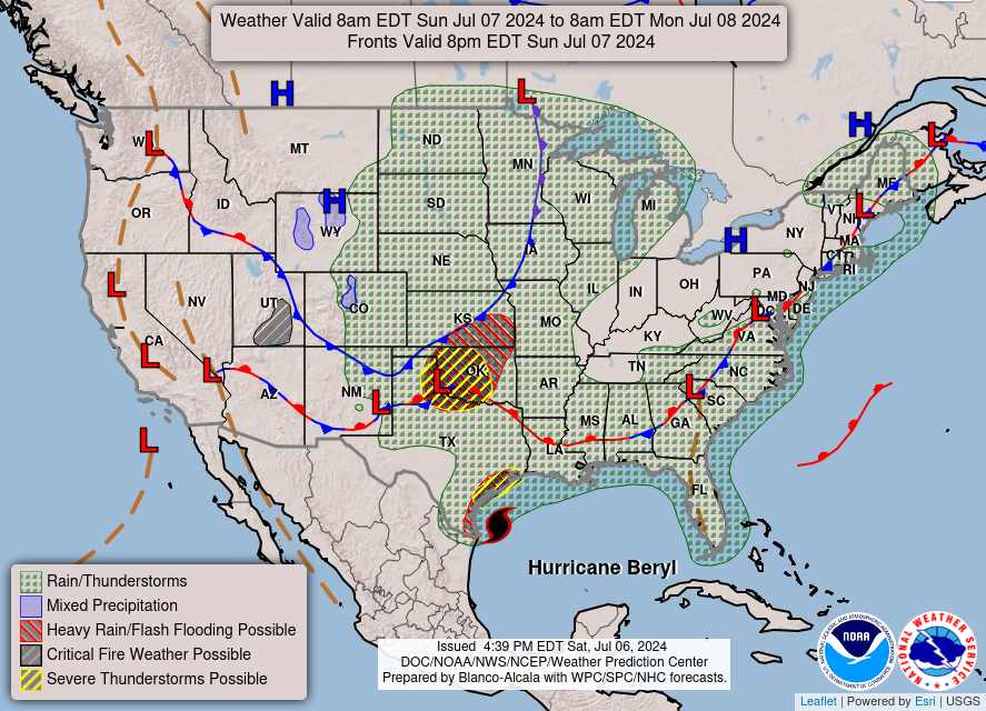
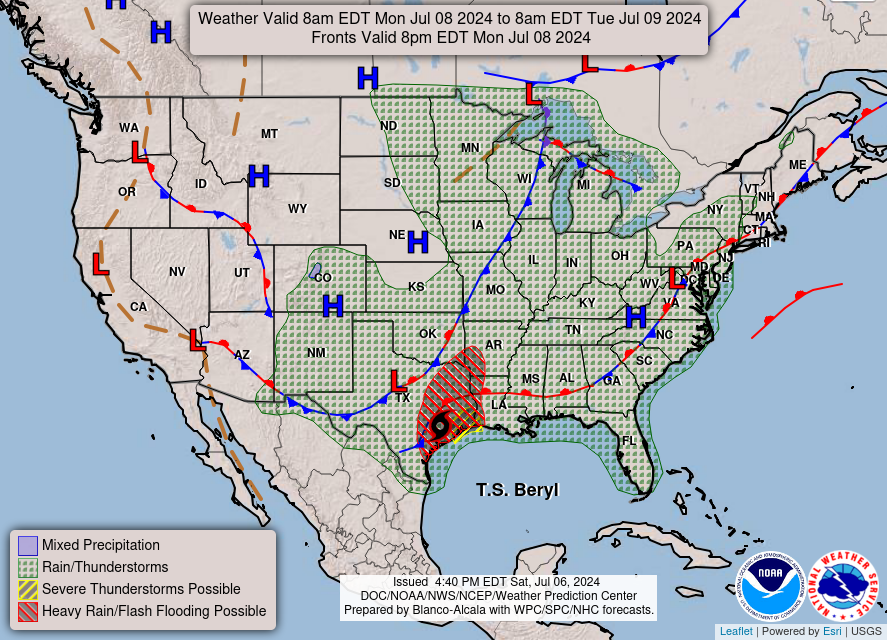
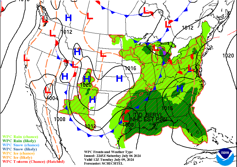
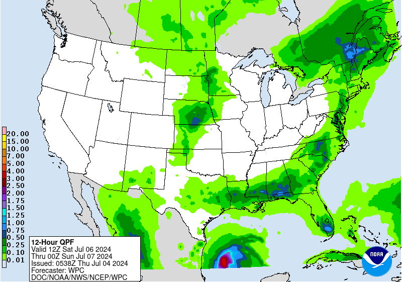
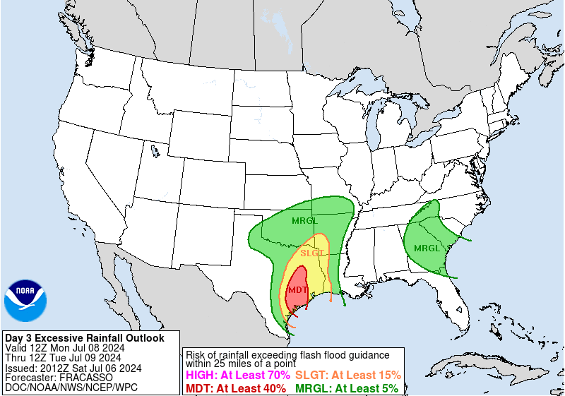
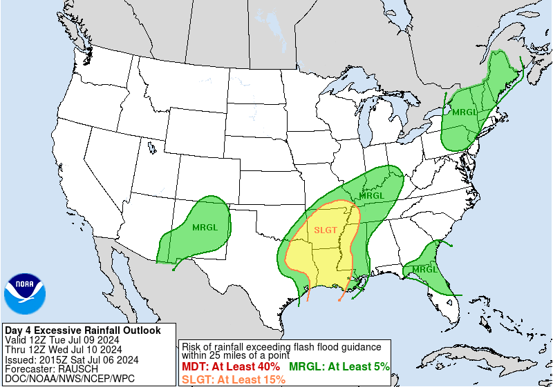
Extended Forecast Discussion
NWS Weather Prediction Center College Park MD
254 AM EDT Thu Jul 4 2024
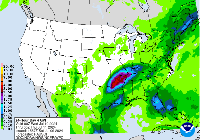
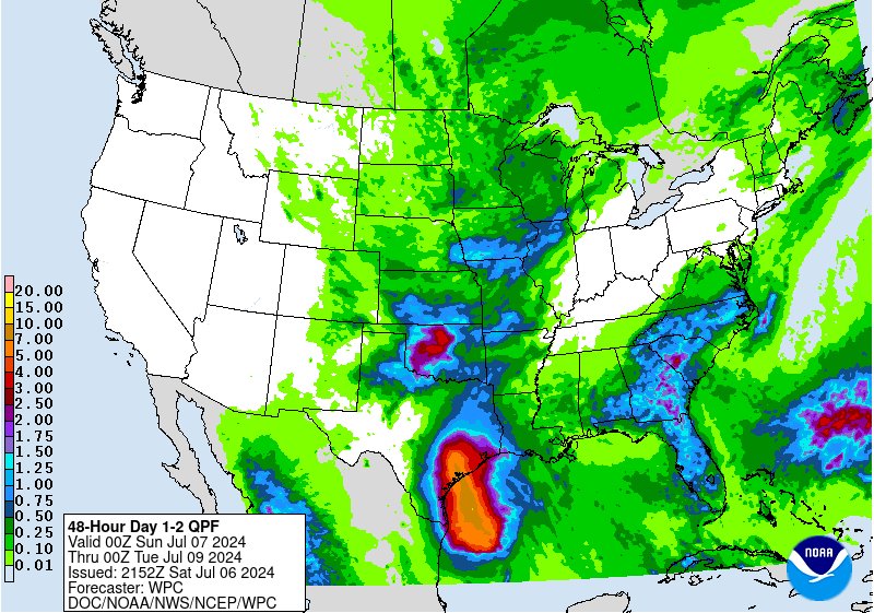
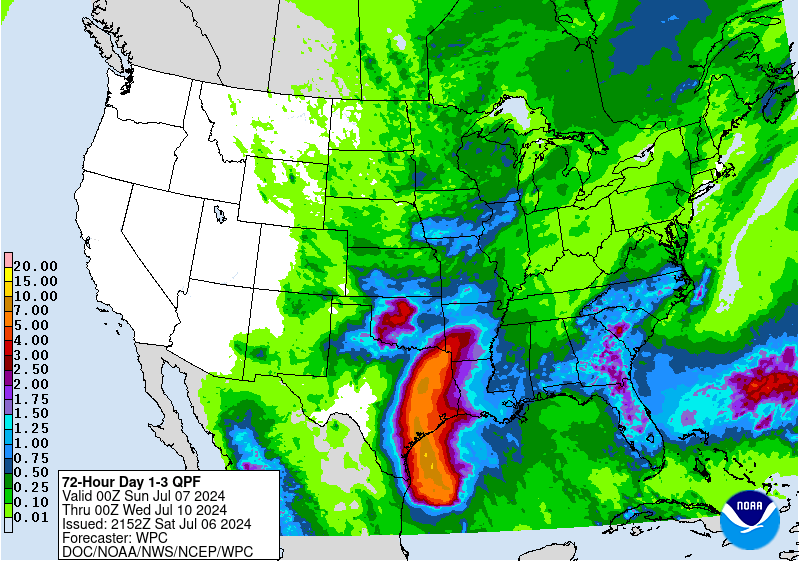
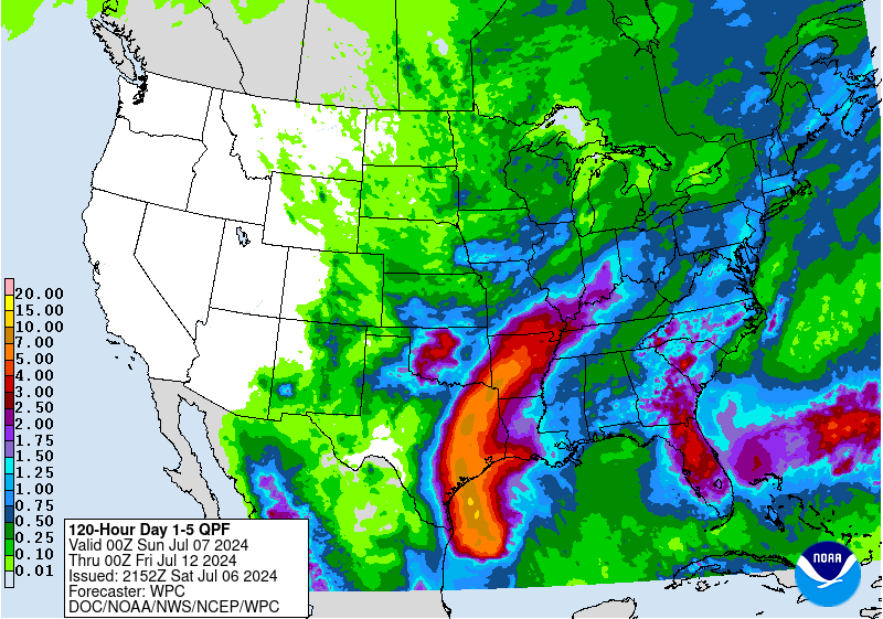
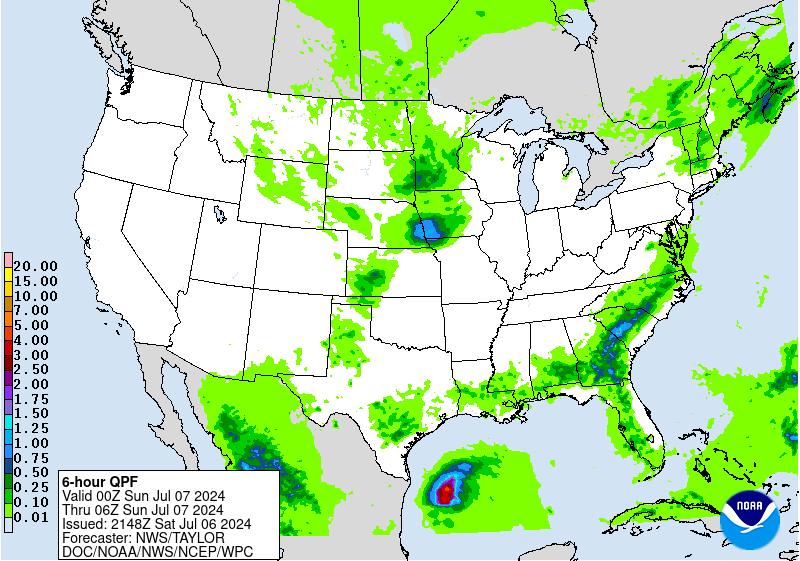
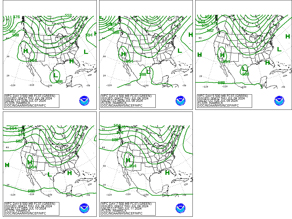
Going into the Day 4 period Sunday, the official NHC track of
Beryl has it making landfall just to the south of Brownsville,
Texas, and a slower forward motion. Given this forecast track,
rain and embedded thunderstorms would be increasing in coverage
across Deep South Texas through the day Sunday into Sunday night,
with the potential for some 3+ inch totals by 12Z Monday south of
Corpus Christi. Therefore, a Slight Risk area is maintained for the
Day 4 ERO for this area, and a broader Marginal Risk area
extending farther northward along the Texas coast to account for
periods of heavy rainfall with the outer rain bands. Farther to the
north across the Central Plains, a Slight Risk area is also
maintained for central Oklahoma into southern Kansas, with
increasing model support for development of some MCS activity
northeast of a surface low and and upper trough.
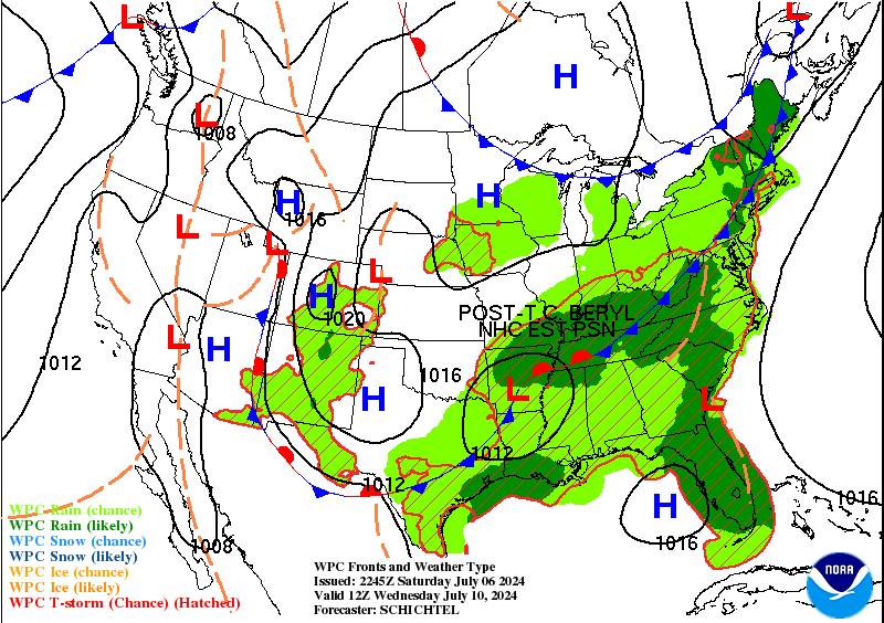
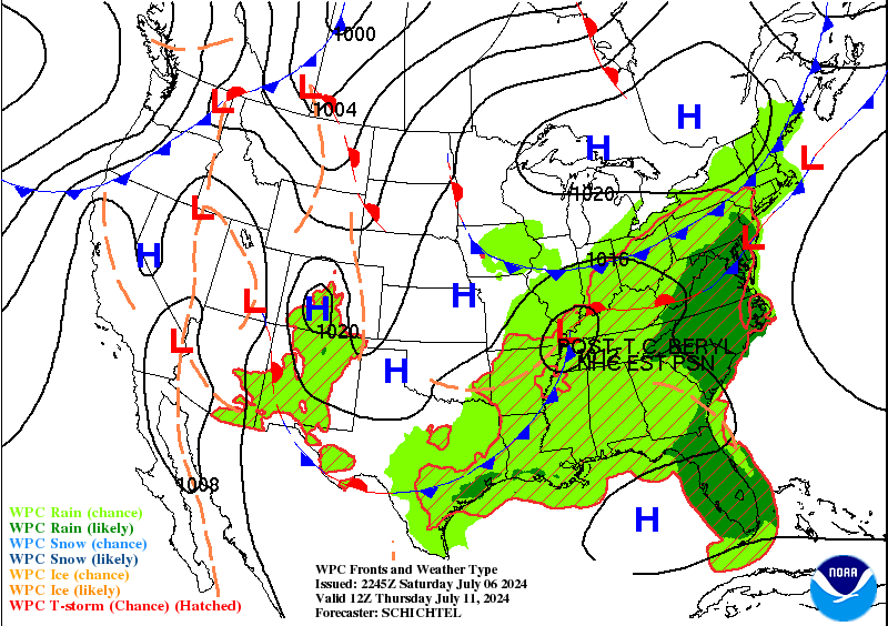
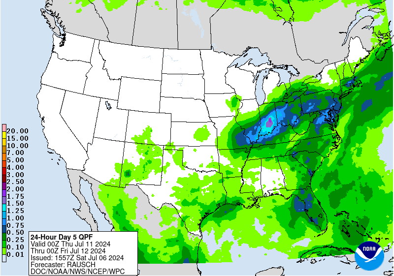
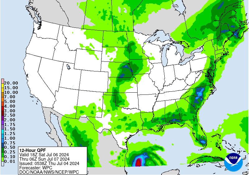
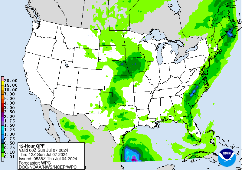
Heavy rainfall concerns continue going into Monday across the Lower
Rio Grande area of Texas as Beryl moves farther inland and weakens.
There is still some notable model differences regarding the
placement of the higher QPF, but given forecast heavy rain the day
prior and the NHC track, a Slight Risk is planned for the new Day
5 ERO for portions of Deep South Texas and extending farther
inland. This is subject to change as the forecast track becomes
more certain and the models get a better handle on the situation. A
separate Marginal Risk is also planned for Day 5 near the Red
River Valley of TX/OK and into Arkansas and Missouri for additional
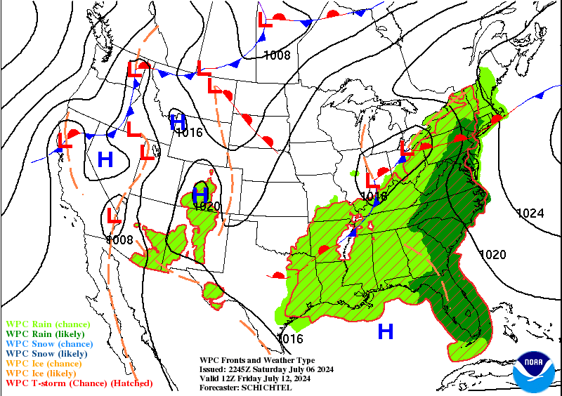
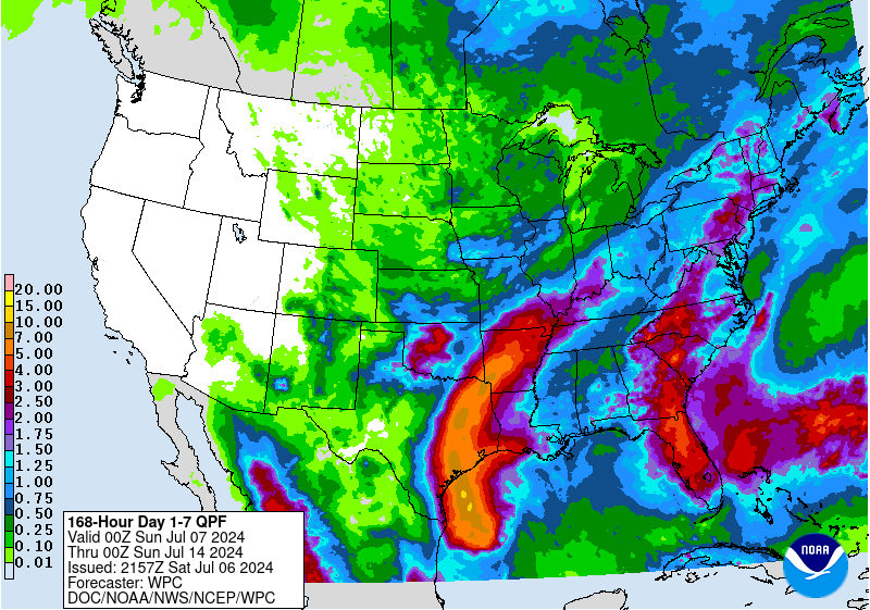
MCS activity. Scattered showers and storms are likely to persist
across much of the Gulf Coast, Deep South, and the East Coast
states going into the middle of next week with a moist and unstable
airmass remaining in place.
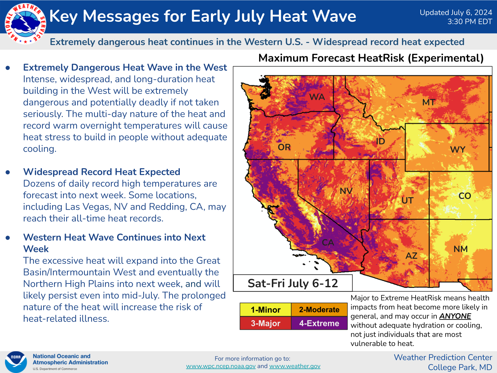
Major heat will continue to make weather headlines for the West
Coast states, with 100+ degree high temperatures extending to
northern Washington for the entire forecast period. Highs will
likely reach the 110s for the lower elevations of inland
California, southern Nevada, and southern Arizona, with some 120s
possible for the normally hotter locations. Some of this extreme
heat will likely expand eastward to include much of the
Intermountain West, including Utah and Idaho where some triple
digits readings are expected. Numerous daily records are likely to
be established during this prolonged and dangerous heat event, with
major to extreme heat stress conditions. Even Wyoming and Montana
get above average temperatures by next Wednesday/Thursday as the
upper ridge slowly moves inland across the Rockies. Elsewhere,
seasonal levels of heat and humidity can be expected most days for
the southern and eastern parts of the country, although there will
likely be some days that reach heat advisory criteria in some
areas.
Hamrick
Extended Forecast Discussion
NWS Weather Prediction Center College Park MD
254 AM EDT Thu Jul 4 2024
Going into the Day 4 period Sunday, the official NHC track of
Beryl has it making landfall just to the south of Brownsville,
Texas, and a slower forward motion. Given this forecast track,
rain and embedded thunderstorms would be increasing in coverage
across Deep South Texas through the day Sunday into Sunday night,
with the potential for some 3+ inch totals by 12Z Monday south of
Corpus Christi. Therefore, a Slight Risk area is maintained for the
Day 4 ERO for this area, and a broader Marginal Risk area
extending farther northward along the Texas coast to account for
periods of heavy rainfall with the outer rain bands. Farther to the
north across the Central Plains, a Slight Risk area is also
maintained for central Oklahoma into southern Kansas, with
increasing model support for development of some MCS activity
northeast of a surface low and and upper trough.
Heavy rainfall concerns continue going into Monday across the Lower
Rio Grande area of Texas as Beryl moves farther inland and weakens.
There is still some notable model differences regarding the
placement of the higher QPF, but given forecast heavy rain the day
prior and the NHC track, a Slight Risk is planned for the new Day
5 ERO for portions of Deep South Texas and extending farther
inland. This is subject to change as the forecast track becomes
more certain and the models get a better handle on the situation. A
separate Marginal Risk is also planned for Day 5 near the Red
River Valley of TX/OK and into Arkansas and Missouri for additional
MCS activity. Scattered showers and storms are likely to persist
across much of the Gulf Coast, Deep South, and the East Coast
states going into the middle of next week with a moist and unstable
airmass remaining in place.
Major heat will continue to make weather headlines for the West
Coast states, with 100+ degree high temperatures extending to
northern Washington for the entire forecast period. Highs will
likely reach the 110s for the lower elevations of inland
California, southern Nevada, and southern Arizona, with some 120s
possible for the normally hotter locations. Some of this extreme
heat will likely expand eastward to include much of the
Intermountain West, including Utah and Idaho where some triple
digits readings are expected. Numerous daily records are likely to
be established during this prolonged and dangerous heat event, with
major to extreme heat stress conditions. Even Wyoming and Montana
get above average temperatures by next Wednesday/Thursday as the
upper ridge slowly moves inland across the Rockies. Elsewhere,
seasonal levels of heat and humidity can be expected most days for
the southern and eastern parts of the country, although there will
likely be some days that reach heat advisory criteria in some
areas.
Hamrick


